VT-NAUT

The best of the performance of a fixed wing aircraft, with vertical takeoff. Land anywhere, even water.

VT-Naut VTOSL (Vertical Takeoff and Short Landing) fixed-wing drone, is an innovative aerial solution meticulously designed to cater to diverse applications, including high-precision mapping, surveying, inspection, scouting, observation, and agriculture, covering very large areas per flight.

DEPENDABLE SIMPLICITY

The VT Naut’s uncluttered tail-sitter design embodies performance and simplicity, ensuring maximum efficiency, unwavering reliability, and cost-effectiveness. Standing at only 3,700 grs gross weight and 2m, the VT Naut its a lightweight and uncomplicated rugged system designed for tough field work. Its simplicity stands in stark contrast to the complexity and expense associated with alternative VTOL designs, avoiding “dead-weight” throughout its flight stages typical of other tilt rotors or multi-motor configurations. Most multirotor VTOL configurations have complex tilt-rotor mechanisms or even up to five motors in order to complete all stages of flight.
The VT Naut low-cost drone boasts Beyond Visual Line of Sight (BVLOS) capabilities, underpinned by a remarkable 30km data link range, up to 90-minute endurance, and an indestructible EPP body design that regains its original shape if bent.

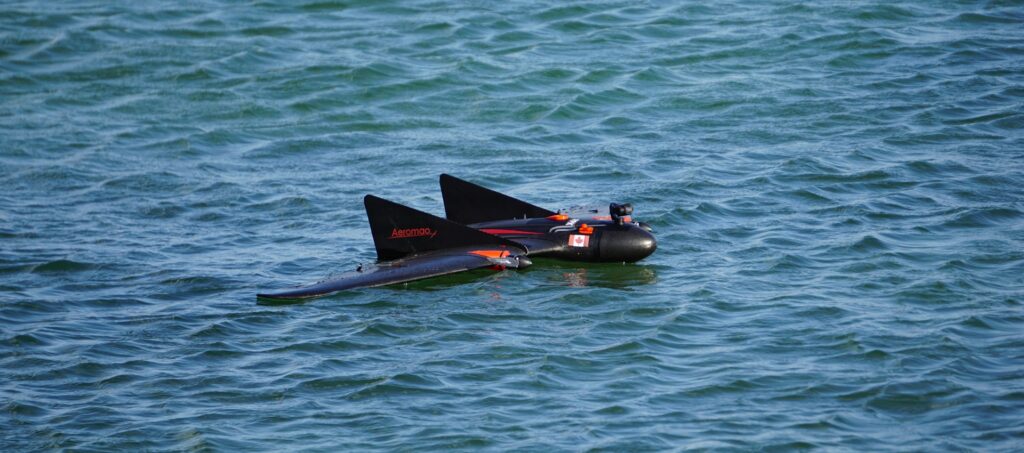
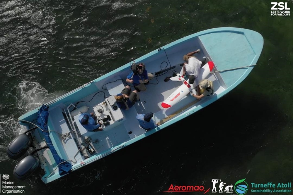
The VT-Naut is the world’s first water landing capable – vertical takeoff fixed wing drone in the market.

Area coverage icon

Maps 540 hectares (1330 acres) at 400ft per flight@3cm/px

Endurance icon

Up to 90 mins endurance

Swappable payloads

Swappable payloads

VT Naut vertical takeoff drone icon 2

Vertical Takeoff

Fully autonomous

Fully autonomous

BVLOS

BVLOS (70 km of linear distance per flight, 30kms link range)

PPK

GNSS PPK centimeter accurate mapping data

Accurate landings

Precision automatic belly landing

WHY SHORT LANDING INSTEAD OF VERTICAL?

While vertical landing fixed-wing (VTOL) drones possess the ability to touch down within minimal spaces, their fabrication often entails increased costs and system complexity, significantly escalating the price tag, and increasing the number of mechanical components that can fail.
Some intricate VTOL drones rely on four vertical flight motors, with one additional motor for horizontal flight, for a total five motors, five Electronic Speed Controllers, a lots of extra cabling. The first four motors and its associated sub-components become “dead weight” for the horizontal cruise phase of flight, accounting for poor aerodynamics and reducing performance.
With over two decades of experience mapping large areas and operating fixed-wing UAVs in seven countries across diverse terrains, we’ve found that in over 85% of cases, there’s ample space for a fixed-wing UAV to execute a cost-effective belly landing.

Fixed wing VTOL drones are designed to survey very large areas, so finding an appropriate spot to launch and recover from is almost always easily possible. A “belly landing drone” translates into a lower-cost drone design which directly benefits the user. A vertical landing fixed wing (VTOL) drone is seldom absolutely necessary unless operating in exceptionally confined spaces such as dense forests or populated areas. The VTNaut caters to those seeking a cost-effective alternative to a full VTOL platform, who has flexibility for site selection for landing and who requires to survey very large areas, at a fraction of the cost of other VTOL fixed wing drones.
Our VTOSL solution lowers the costs and complexity of the operations, while increasing the dependability. Simplicity equals reliability.
Moreover, the VT Naut integrates sensors designed to facilitate pinpoint-accurate short landings, minimizing the required landing space.

AMPHIBIOUS CAPABILITY

Building on the success of our acclaimed Aeromapper Talon Amphibious, we have expanded our offerings to include an amphibian variant of the VT Naut, enabling safe landings on water, including saltwater bodies. This enhancement positions the VT Naut as the preferred drone for marine applications requiring a Long-Range, Long-Endurance Fixed-Wing UAV. The demand for marine shipboard operations has grown significantly worldwide, and our drone’s ability to safely land on water provides a distinct advantage.

Aeromao has actively engaged in international exercises combating illegal fishing in marine protected areas, employing our Aeromapper Talon water-landing fixed-wing drones.. Some of these cases are mentioned here. The Aeromao VT-Naut stands as the world’s first vertical takeoff water landing fixed-wing drone for ship-board or coastal operations. It revolutionizes fixed-wing drone implementation from ships by eliminating challenges such as hand launches, complex launching methods, and the need for intricate landing mechanisms, catching nets or risky hand-catching multirotor drones on deck. The VT Naut expands the scope of conservation and protection efforts cost-effectively, liberating users from the limitations of small multirotor drones such as endurance and range.

VT-NAUT Features

VT Naut VTOL fixed wing drone takeoff square low size

Uncluttered, unaltered pure breed fixed wing performance. The clean aerodynamic design of the VT-Naut has no tilt mechanisms that can fail, no extra booms, no additional motors for vertical flight., no unnecessary weight.

Indestructible materials: thanks to its compact body design and EPP material the VT Naut suffers no damage even in the toughest environments and harshest handling. The body material recovers its shape after impact and cannot be bent or cracked.

Indestruc
VT NAUT+REACH

Order VT Naut with the Emlid Reach M2 PPK UAV Mapping kit to drastically cut the number of ground control points (GCPs) and to take the accuracy to centimeter levels even in remote areas. Includes the Reach M2 Multi-band GNSS receiver onboard and Reach RS2+ RTK GNSS receiver as base. System tracks GPS/QZSS (L1, L2), GLONASS (L1, L2), BeiDou (B1, B2), Galileo (E1, E5) constellations and works over longer baselines of up to 100 km in PPK mode.

Strong winds? Bring it on! The VTNaut capitalizes on strong winds during the landing phase, actually facilitating a shorter landing. Wind poses no obstacle during takeoff, although it is advisable to limit flights to wind speeds under 35 km/h.

Strong wings
Capture 9

Long Endurance: 90 min endurance. An even longer endurance version is currently in the works.

BVLOS: Beyond Visual Line of Sight capable thanks to its 30km data link range and 70 km linear missions.

VT Naut BVLOS link range
Multi payloads

Multipayload: up to 61 Mp high resolution for mapping with GNSS PPk module, HD video long range surveillance package and multispectral sensors are available for the VT-Naut. Explore the growing list of payload options available for VT-Naut here.

Low cost: the VT-Naut is available at just a fraction of the cost of a conventional VTOL drone available.

Capture 29
TRansport Canada compliant low size

Transport Canada compliant status: Coming soon..

The VT-Naut is also easier to transport and setup. 3,600grs of weight including payload and battery. Setup in 2 minutes.

VT Naut parts 1-crop low size
Aeromao VTOL test low size

Backed by more than 20 solid years of experience in commercial operation and manufacture of fixed-wing UAVs. The VT-Naut is another pioneering turnkey UAV system that has been on development and testing since 2021.  Offered with a 12-month warranty and unlimited after-sale support, every single unit is flight tested before delivery.

ID remote is now available on request. Comply with USA and Euro requirements for remote ID. We are official dealers of Dronetag Remote ID solutions.

Vt Naut VTOL drone remote ID equipped red brush effect low size

Construction:  EPP foam with carbon fiber reinforcements. EPP is basically indestructible.
·       Wingspan:  1.96 m.
·       Empty Weight: 3100 grs.
·       Maximum payload capacity: 500 grs
·       Endurance: 1.5 hours.
·       Takeoff: Automatic vertical takeoff
·       Landing:  Automatic precision belly landing on ground or water.
·       Communications Link Range: +30kms.
·       Cruise speed: 55 Km/h.
·       Payloads:
– 24Mp, 36Mp and 61 Mp RGB for mapping (Nadir).
– 20Mp RGB for mapping (Nadir for amphibious configuration).
– 4K 8Mp HD 3 axis gimbal for observation and surveillance, with HD digital video downlink up to 21Kms of link distance.

·      ADS-B: Live air traffic data system displays altitude, map position, ICAO number, Call Sign, Squawk code, speed and heading of nearby aircraft within up to a 100km radius.
·       Wind Tolerance: up to 35 km/h
·       Maximum speed: +85 Km/h
·       Failsafe: Automatically returns to home & loiter upon loss of RC link. Other failsafe routines are available.
·       Telemetry: Battery status, alt, ground speed, compass, altitude, distance traveled, time on air (speech enabled), and much more (aprox 200 more selectable information items).
·       Moving map display: Drone position and heading, commands on map, fly to point on map, altitude changes, remote spot camera trigger, mission route, and more.
·        Weather:  it can fly in light rain or snow. The amphibious variant is fully waterproof.
·       People required for operation: one operator.
·       Set up time: 2 minutes.
·       Temperature range: -20 o C to +40 o C.
·       Year of introduction to the market: 2023

–  VT-Naut Unmanned System Ready to Fly.
–  One set of batteries & charger.
–  30 Km Telemetry Link system.
–  User’s Manuals & Documentation.
–  Heavy duty carrying case.
–  Unlimited support and 12-month warranty.
–  Mission Planner Software.

PAYLOADS AVAILABLE:

Our VT-Naut offers a spectrum of adaptable payloads, each meticulously engineered for specific applications:

MAPPING

Choose between 24 Mp, 42 Mp or 61 Mp high resolution survey grade mapping cameras for the maximum productivity.

Multiply your productivity, get centimeter accuracy and save money and time on large projects by adding the Reach M2 UAV PPK Mapping kit.

SURVEILLANCE

Elevate your surveillance capabilities to unprecedented heights with an economical yet remarkably versatile solution tailored for surveillance, observation, and scouting endeavors—an advanced 3-axis 4K High-Definition Long-Range video downlink system. Ideal for an array of applications, including wildlife monitoring, search operations, conservation and inspections, this cutting-edge system ensures optimal performance.

The system is available for the amphibian variant of the VT Naut, presenting an unparalleled solution for marine operations and ship-board missions. Video link range to 21 kms from operators. Find more information here.

AGRICULTURE

Chose the Micasense Rededge P to obtain calibrated multiespectral imagery.

RedEdge-P features a high-resolution panchromatic band for pan-sharpened output resolutions of 2 cm / 0.8 in at 60 m / 200 ft.

Its five narrow multispectral bands with scientific-grade filters make it the perfect camera for calculating multiple vegetation indices and composites.