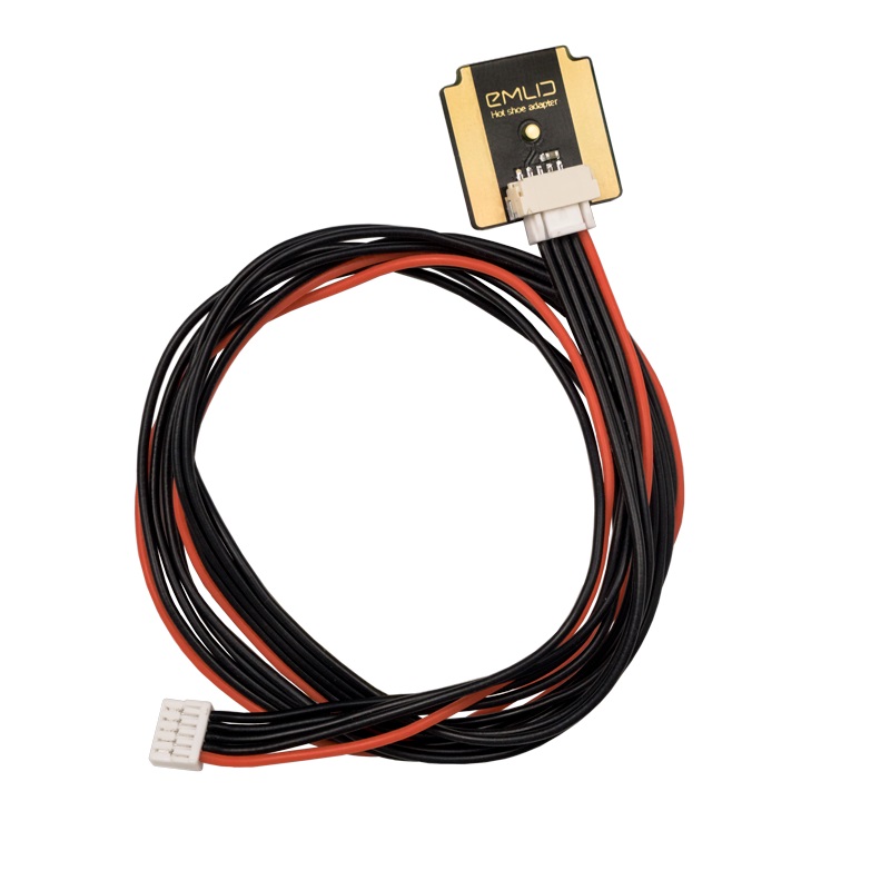
Network RTK rover with centimeter accuracy Pocket-sized and lightweight receiver.
Works with NTRIP corrections.
When paired with the signature Emlid survey-pole, the Reach RX becomes the most simple measurement/locating tool on the job site. Centimeter-level accuracy that is fast, light, and so incredibly useful.
It is just that: the usability and the ease of use, that raises the level of productivity, for both skilled professionals and laypeople.
Install the ReachView app now and take a few moments to get familiar: [Android app – free], [iOS app – free].
Then, after unpacking your new Reach RX, you can be collecting your first point in 60 seconds.
just add NTRIP. Reach RX uses Bluetooth, allowing you to connect and start surveying in a few seconds. No settings to get wrong.
1. Enable Bluetooth on your device and find your Reach RX in ReachView 3.
2. Add network correction credentials
3. Collect your first point.
AVAILABLE AS A: Network Base and Rover kit Reach RX Kit Reach RX Team kit
Reach RX uses the Bluetooth LE connection to your phone/tablet to receive a feed from the Internet, via an NTRIP[?] caster, so you’ll need some NTRIP credentials.
But don’t worry if you don’t have NTRIP credentials at the moment, because you could
Accomplish your basic surveying goals with the ReachView 3 app
Import and export points from ReachView 3 in various formats, such as Shapefile, DXF, and CSV.
Whether you collect, then export the points; or import, then stake-out the points; or just do everything you need within ReachView, you are assured of a simple process with universal options for moving your data in and out.
You could use your favorite third-party surveying/GIS app as well. There are techniques to make your device get its location from Reach RX, which allows any app to work with the accuracy of Reach RX. Some third-party apps will be able to work directly with Reach RX as well.
Technical training is not required
Compact and rugged:
Industrial battery:
GNSS
Deployment:
For surveying, mapping and navigation.
Comes with a mobile app.
LTE modem
Baseline up to 100 km
Update rate 10 Hz
LTE modem
Regions Global
Bands FDD-LTE: 1, 2, 3, 4, 5, 7, 8, 12, 13, 18, 19, 20, 26, 28, 66
TD-LTE: 38, 40, 41
UMTS (WCDMA/FDD): 1, 3, 2, 4, 5, 6, 8, 19
Quad-Band, 850/1900, 900/1800 MHz
SIM card Nano-SIM
Gets a fix in seconds.
Reach RS2+ gets a fixed solution in just seconds and maintains robust performance even in challenging conditions. Centimeter accuracy can be achieved on distances up to 60 km in RTK, and 100 km in PPK mode
PPP support:
RINEX raw data logs are compatible with PPP services so you can now get centimeter-precise results in any place on Earth. Process RINEX files in an online service and get position with absolute accuracy.
Built-in LTE modem
Reach RS2+ features a power-efficient LTE modem with 2G/3G fallback and global coverage. Now corrections can be accessed or broadcasted over NTRIP independently, without relying on an Internet connection on your phone.
22 hours on 1 charge:
Up to 22 hours of autonomous work when logging data and up to 16 hours as a LTE rover, even in cold weather. Reach RS2+ can charge from a USB wall charger or a power bank over USB-C.
Surveying with ReachView 3:
With ReachView 3, you can collect and stake out points and control all the features of Reach receivers, such as setting up a base station, logging RINEX data, and configuring NMEA output.
The app is available both for Android and iOS, supports thousands of coordinate systems and is translated into multiple languages.
Point collection: save points, and export data to CSV:
Record each position as a point with centimeter precise coordinates. Export projects and open them in GIS or CAD software like AutoCAD, ArcGIS, QGIS, and others.
Coordinate systems based on WGS84, NAD83, GDA2020, and others
Logging in RINEX: record raw data, position, and base correction logs
Record raw data, position and base correction logs. Point collection and recording of RAW data are independent processes and can be used simultaneously. ReachView 3 has a simple and intuitive interface for logging configuration and control.
We provide our version of RTKLib for PPK. It’s free and can be downloaded from our docs.
Reach RS2+ needs a base station as a source of corrections. That’s a requirement for centimeter accuracy in RTK and PPK. Base might be either another Reach RS2+ receiver or an NTRIP service. VRS is also supported.
Read more details on Emlid’s Official website here:
Centimeter accuracy for surveying, mapping and data collection.
Package includes:
– Two Reach RS2
– Two Carrying cases with a strap
– Radio antennas
– USB Type-C cables
OPTIONAL ACCESSORIES:
Positioning with centimeter accuracy in RTK and PPK. For precise UAV mapping with less GCPs.
Reach provides very accurate positioning by connecting directly to the camera hot shoe port, which is synced with the shutter. The time and coordinates of each photo are logged with a resolution of less than a microsecond. This method allows GCPs to be used only to check your accuracy.
Compatible with Aeromappers fixed wing drones
Swappable with all other Aeromapper payloads
Also available as stand alone modules or full mapping kits
NTRIP or another Reach as a base station To calculate centimeter-precise coordinates in PPK and RTK, Reach needs corrections from a base station. It could be either another Reach receiver or an NTRIP service. VRS is also supported.
Compatibility Reach M2 and M+ work seamlessly with other Reach receivers over any link and are compatible with any other receiver that supports RTCM3 and NTRIP.
If you work within short baselines, then Reach M+ is an optimal choice.
Frequency bands: Single band
Time to fix: 1-2 minutes
RINEX logging update rate: Up to 14 Hz
It provides robust performance and quick initialization, allowing work on long baselines.
Frequency bands: Multiband
Time to fix: 5 seconds
RINEX logging update rate: Up to 14 Hz
1. Fly the drone, Reach will record photo events.
Reach captures flash sync pulses with sub-microsecond resolution and stores them in a raw data RINEX log in the internal memory
2. Download logs from Reach and base station.
After the flight, get the RINEX logs from your airborne Reach module and a base station (Reach RS, CORS or another receiver).
3. Process logs and get a file with geotags of photos.
Process RINEX files using free RTKLIB software. The produced file with precise coordinates of the photos can be used for georeferencing.
ReachView is the most user-friendly software for data collection that is available both for Android and iOS. With ReachView, you can control all the features of Reach receivers, such as setting up a base station, logging RINEX data, configuring NMEA output, and monitoring data.
Reach is able to trigger cameras as well as register events. The event mark feature is a must for aerial mapping as it allows the precise time when the shutter was activated to be registered.
Logs are automatically recorded directly to RINEX in the internal memory. View a list of the logs and download them using the ReachView app.
ReachView shows current satellite levels, your location on a map, and much more.
3DroneMapping completes PPK trials with the average zero mean error in all axes
Luke Wijnberg, 3DroneMapping.com
As a brief synopsis of the results, the maximum deviation of points was no more than 0.09m in all axes. This is an incredible result given the fact that the average pixel size of the resulting imagery was 0.045m. The average mean error in all axes is just few mm!
The most user-friendly software for data collection that is available both for Android and iOS. With ReachView, you can collect and stake out points and control all the features of Reach receivers, such as setting up a base station, logging RINEX data, and configuring NMEA output.
Point collection: create projects, save points, and export in industry standard formats. Record each position as a point with centimeter precise coordinates. Export projects and open them in GIS or CAD software like AutoCAD, ArcGIS, QGIS, and others.
Formats: DXF, CSV, GeoJSON, ESRI Shapefile
Stakeout is used to find exact physical locations of points. They can be collected in ReachView or imported from other CAD or GIS software. Process of stakeout in ReachView has two steps: map view and bulls-eye. Map’s purpose is to help you navigate to points on long distances. When you get closer than 40 cm to the point, bulls-eye turns on to make it easier for you to visually match receiver and point.
Formats: CSV, DXF and GeoJSONs
Record raw data, position and base correction logs. Point collection and the recording of RAW data are independent processes and can be used simultaneously. ReachView has a simple and intuitive interface for logging configuration and control. We provide our version of RTKLib for PPK. It’s free and can be downloaded from our docs.
STORAGE
REACH RS2
16 GB: 160+ days of logging at 1 Hz
REACH RS+
8 GB: 80+ days of logging at 1 Hz
PPP for OPUS
RINEX raw data logs are compatible with PPP services so you can now get centimeter-precise results in any place on Earth. Process RINEX files in an online service and get position with absolute accuracy.
Real-time position streaming in NMEA
Reach provides data in standard NMEA that is used by most GIS apps. Simply connect your device to Reach over Bluetooth or with a cable, and turn on “Position output” in ReachView.
Reach can turn on and off automatically
Reach is able turn on and off in sync with an external battery connected over RS-232. This helps when the power button is hard to reach. For example, if the receiver is placed on the roof of a tractor.
Compatible apps: MachineryGuide, AgriBus-Navi, Efarmer, Agripilot, and others
Position streaming: Interfaces RS-232, TCP, Bluetooth
NTRIP or another Reach as a base station
Reach RS2 needs a base station as a source of corrections. That’s a requirement for centimeter accuracy in RTK and PPK. Base might be either another Reach RS2 receiver or an NTRIP service. VRS is also supported. Reach RS2 works seamlessly with other Reach receivers over any link.
Input and output corrections: Interfaces TCP, LoRa, Bluetooth, RS-232, NTRIP
Formats: RTCM3
REACH RS2
Over 60 km in RTK
100 km in PPK
Any place on Earth with PPP
REACH RS+
Up to 10 km in RTK
20 km in PPK
Engineered to be tough: Reach RS bases are designed to work even in the most challenging environments.
IP67: RS2 is waterproof up to 1 m depth. All connectors are completely sealed and protected from water and dust with silicone plugs.
-20ºС…+65ºС: We extensively tested Reach RS2 in conditions that simulate coldest winters and hottest summers.
Polycarbonate body: Polycarbonate, an extremely durable material that is used in bulletproof glass, makes Reach RS2 impact-resistant.
Rugged 5/8″ mount: A precision CNC machined threaded mount is inserted.
30 hours battery life: Industrial LiFePO4 battery that doesn’t die of cold. Can charge over USB from a powerbank.