Description
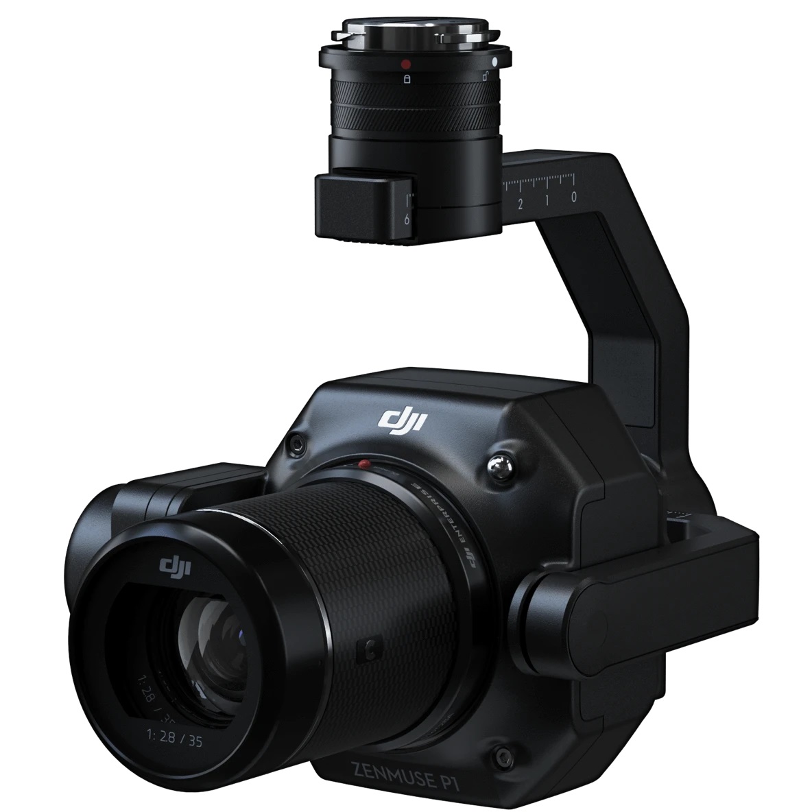
Zenmuse P1
Efficiency through Flexible Full-frame Photogrammetry
The Zenmuse P1 integrates a full-frame sensor with interchangeable fixed-focus lenses on a 3-axis stabilized gimbal. Designed for photogrammetry flight missions, it takes efficiency and accuracy to a whole new level. The new benchmark for aerial surveying.
Your Go-to Tool for Aerial Photogrammetry
Extraordinary Efficiency
The P1 includes a full-frame, low-noise high-sensitivity sensor that can take a photo every 0.7 s during the flight, and covering 3 km2 [2] in a single flight.
Remarkable Accuracy
Equipped with a global mechanical shutter and the all-new TimeSync 2.0 system, which synchronizes time across modules at the microsecond level, the Zenmuse P1 lets users capture centimeter-accurate data combined with the real-time position and orientation compensation technology.
Robust Versatility
Create 2D, 3D, and detailed models thanks to the integrated 3-axis gimbal that can be outfitted with 24/35/50mm lenses and the Smart Oblique Capture feature.
Efficiency to Cover It All
Full-frame Camera
– 45MP Full-frame Sensor
– 4.4μm Pixel Size
– Low-noise, high sensitivity imaging extends daily operational time
– Take a photo every 0.7 s during the flight
– TimeSync 2.0 aligns the camera, flight controller, RTK module, and gimbal at the microsecond level
Work Smart, Work Fast
Smart Oblique Capture
Cover 7.5 km2 [4] in a single workday with the P1. Elevate the efficiency of your oblique photography mission using Smart Oblique Capture, where the gimbal automatically rotates to take photos at the different angles needed. Only photos essential to the reconstruction will be taken at the edge of the flight area, increasing the efficiency of post processing by 20%[5] to 50%[6].
Smart Data Management
Your mission data management – streamlined.
Mission result files are automatically associated with the Mission Name and Mission Time.
A centralized storage location for photos, GNSS data, and TimeStamps. MRK files.
The image metadata contains the camera’s intrinsic and extrinsic parameters and the status of RTK.
Fieldwork Report
Verify data quality immediately post-flight by checking the position data and number of the images acquired, as well as RTK status and positioning accuracy.
A Mission Mode for Any Scenario
Application Scenarios
Capture data that meet the 1:500 scale accuracy requirements without GCPs.Cadastral Surveying
Quickly generate centimeter-level accurate 3D reality models.
AEC and Surveying
Manage the full project lifecycle with 2D and 3D drone data.
Natural Resource Management
Measure, classify, or determine the ownership of water bodies and forests.
Geological Investigation
Safely gather millimeter-level accurate aerial data of geological hazard sites.
Disaster Site Modeling
Gain real-time overviews of vast disaster-struck areas to help teams make critical decisions.
Specifications
| Category | Item | Spec |
|
General
|
Weight | Zenmuse H20: 678±5 g Zenmuse H20T: 828±5 g |
| Dimensions | Zenmuse H20: 150×114×151mm Zenmuse H20T: 167×135×161mm |
|
| Ingress Protection Rating | IP44 | |
| Operating Temperature | -20° to 50° C (Temperature Measurement is only available between -10° to 50° C) | |
| Storage Temperature | -20° to 60° C | |
| Laser Safety | Class 1M (IEC 60825-1:2014) | |
| Supported Aircraft | Matrice 300 RTK | |
|
Gimbal
|
Angular Vibration Range | ±0.01° |
| Mount | Detachable | |
| Controllable Range | Pitch: -120° to +30° Yaw: ±320° |
|
| Mechanical Range | Pitch: -132.5° to +42.5° Yaw: ±330° Roll: -90° to +60° |
|
|
Zoom Camera
|
Sensor | 1/1.7″ CMOS, 20 MP |
| Lens | DFOV: 66.6°-4° Focal length: 6.83-119.94 mm (equivalent: 31.7-556.2 mm) Aperture: f/2.8-f/11 (normal),f/1.6-f/11 (night scene) Focus: 1 m to ∞ (wide), 8 m to ∞ (telephoto) |
|
| Focus Mode | MF/AF-C/AF-S | |
| Exposure Mode | Auto, Manual | |
| Exposure Compensation | ±3.0 (1/3 increments) | |
| Metering Mode | Spot metering, Center-weighted metering | |
| AE LOCK | Supported | |
| Electronic Shutter Speed | 1 ~ 1/8000 s | |
| ISO Range | Video: 100 – 25600 Photo: 100 – 25600 |
|
| Video Resolution | 3840×2160@30fps, 1920×1080@30fps | |
| Video Format | MP4 | |
| Video subtitles | Supported | |
| Photo Size | 5184 × 3888 | |
| Photo Format | JPEG | |
|
Wide Camera
|
Sensor | 1/2.3″ CMOS, 12 MP |
| Lens | DFOV: 82.9° Focal length: 4.5 mm (equivalent: 24 mm) Aperture: f/2.8 Focus: 1 m to ∞ |
|
| Exposure Mode | Auto | |
| Exposure Compensation | ±3.0 (1/3 increments) | |
| Metering Mode | Spot metering, Center-weighted metering | |
| AE LOCK | Supported | |
| Shutter Speed | 1 ~ 1/8000 | |
| ISO Range | Video: 100 – 25600 Photo: 100 – 25600 |
|
| Video Resolution | 1920×1080@30fps | |
| Video Format | MP4 | |
| Video subtitles | Supported | |
| Photo Size | 4056 x 3040 | |
| Photo Format | JPEG | |
|
Thermal Camera (Zenmuse H20T)
|
Sensor | Uncooled VOx Microbolometer |
| Lens | DFOV: 40.6° Focal length: 13.5 mm (equivalent: 58 mm) Aperture: f/1.0 Focus: 5 m to ∞ |
|
| Digital Zoom | 1x, 2x, 4x, 8x | |
| Video Resolution | 640×512 @ 30 Hz | |
| Video Format | MP4 | |
| Image Resolution | 640×512 | |
| Image Format | R-JPEG* (16 bit) | |
| Pixel Pitch | 12 μm | |
| Spectral Band | 8-14 μm | |
| Sensitivity (NETD) | ≤50 mK @ f/1.0 | |
| Temperature Measurement Method | Spot Meter, Area Measurement | |
| Scene Range | -40 °C to 150 °C (High Gain) -40 °C to 550 °C (Low Gain) |
|
| Temperature alert | Supported | |
| FFC | Auto/ manual | |
| Palette | White hot/Fulgurite/Iron Red/Hot Iron/Medical/Arctic/Rainbow 1/Rainbow 2/Tint/Black Hot | |
|
Laser Rangefinder
|
Wave length | 905 nm |
| Measurement range | 3-1200 m (to a vertical surface with ≥12m diameter and 20% reflection rate) | |
| Measurement accuracy | ± (0.2 m + D×0.15%) D is the distance to a vertical surface |
|
|
Features
|
Hybrid Optical Zoom | 23× |
| Max. Zoom | 200× | |
| One Click Capture | One click to save the video or picture of 3 cameras (zoom, wide and thermal camera) simultaneously | |
| Point to Aim | Double click on the wide/thermal camera view, then the system will automatically move the gimbal to focus on the point of interest | |
| High-Res Grid Photo | Frame an area of interest in wide camera view, and the zoom camera will automatically capture a set of 20 MP images of the area. These images are stored together with an overview image that can be viewed in greater detail. | |
| Night Scene | Supported (zoom camera) | |
| Timestamp | Including GPS, date and time | |
|
Storage
|
Supported SD Card | MicroSD card (Max capacity: 128 GB,UHS-1 Speed Grade 3 required) |
| Supported File Systems | FAT32 (≤ 32 GB), exFAT (> 32 GB) | |
| Recommended Micro SD Cards | TOSHIBA EXCERIA PRO 32GB micro SD HC SanDisk_Extreme PRO_32GB_3_A1_micro SD V30 HC TOSHIBA EXCERIA PRO 64GB micro SD XC SanDisk_Extreme PRO_64GB_3_A2_micro SD V30 XC SAMSUNG_EVO_128GB_micro SD 3 XC TOSHIBA EXCERIA M303E 32GB micro SD HC TOSHIBA EXCERIA M303E 64GB micro SD XC TOSHIBA EXCERIA M303E 64GB micro SD XC TOSHIBA EXCERIA M303 128GB micro SD XC SAMSUNG_EVO_64GB_micro SD 3 XC |