Professional mapping is not only a task of taking pictures with the help of a drone. For a big project, a drone has to stay up in the air for a while to collect valuable information, follow the route, and capture the right images for the correct outcome. That is especially true in a remote area, construction site, forest, farm, and other places where repeated launches could slow down the work process.
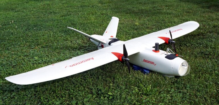
This is the case with Aeromapper Talon. It is a fixed-wing UAV that specializes in functions such as professional mapping, surveying, scouting, and remote sensing. In this guide, we will discuss the features of the aircraft and their impact on the workflow of professional mapping and in what cases using such a type of plane is a good idea.
What Is the Aeromapper Talon?
The Aeromapper Talon is an unmanned aerial vehicle designed for large-scale area coverage and photogrammetric operations. Rather than opting for any additional bells and whistles, the manufacturer goes for a single concept: it should be durable enough to take the abuse, easy to repair on the ground, and made for pilots who operate it frequently rather than once or twice per year on a single task.
This concept affects all other features of the system, from airframe materials used in the construction to payload bay design and spare parts ordering and distribution. After understanding this concept, all the remaining features will seem much more logical, as all of them follow the same idea.
Key Features That Make the Aeromapper Talon Ideal for Mapping
Long Flight Time for Bigger Coverage Per Flight
The flight endurance capacity of the Aeromapper Talon is up to two hours for the standard mapping system, allowing more surveying to be accomplished before any interruption. It becomes suitable for the surveying of farmlands, forests, mining areas, construction, environmental monitoring, and other similar projects requiring wide survey coverage.
According to Aeromao Inc., in an ideal configuration, the Talon can cover up to 480 hectares of land per hour at 1.5 cm/pixel. Actual coverage depends on factors such as altitude, camera, image overlap, terrain, weather, wind, and ground sampling distance, so careful mission planning remains important.
High-Resolution Imaging
The aircraft can be equipped with the Sony ILX-LR1 61 MP mapping camera. High-resolution images are essential since the quality of the output map largely relies on the images acquired in the field.
High-quality images help in generating orthomosaics, DEM/DSM, and point clouds, among other maps, using photogrammetric methods. The camera is therefore part of the complete data chain, from flight planning and image capture to processing and final analysis.
Reliable Payload Options for Different Mapping Needs
Not all applications require the same type of sensors. The Talon offers RGB cameras for ordinary mapping operations, as well as multispectral sensors for such specialized tasks as assessing crop health. This makes it possible to use a single airframe to perform several different functions, rather than having to buy an entirely new drone for each application.
For specialized environments, the Aeromapper Talon Amphibious extends this flexibility to marine and coastal mapping missions where conventional landing areas may not be available.
Durable, Field-Ready Build
Its EPP foam airframe takes a hit without falling apart, and parts can be repaired or swapped out in the field rather than shipped off for weeks of downtime. For a working professional, that kind of practical toughness matters just as much as raw flight specs, since a drone sitting in a repair shop is not earning anyone money.
PPK for More Accurate Positioning
Accurate positioning is another key part of professional mapping. The Aeromapper Talon can be configured with the Emlid Reach M2 PPK UAV Mapping Kit. PPK, or Post-Processed Kinematic positioning, uses GNSS data collected during the mission and processed afterward to improve the position assigned to captured images.
Aeromao Inc. states that this setup can provide centimetre-level accuracy and reduce or eliminate the need for ground control points in suitable workflows. This can simplify field setup and strengthen the geographic accuracy of captured images, although the best workflow depends on project and site requirements.
Consistent Flight Paths for Clean, Usable Data
Controlled height and speed ensure each pass is consistent, which is precisely what is required for photogrammetry programs to create a seamless orthomosaic image. Any inconsistencies in the flying pattern will appear in the orthomosaic as missing spots or blurred areas, which is a flaw that does not happen with the Talon because of its design.
Real-World Example: The Aeromapper Talon Amphibious in the Great Pacific Garbage Patch
The value of a professional fixed-wing platform becomes even clearer when the operating environment is difficult. An example that stands out is the Aeromapper Talon Amphibious, which is specifically adapted for operations in the sea environment.
In one project associated with The Ocean Cleanup, the Talon Amphibious was deployed from a boat to capture aerial imaging data in relation to the Great Pacific Garbage Patch. In this case, the drone would take off and land from the sea, and its long-range abilities enabled operations beyond visual line of sight.
What is important to note here is that not all mapping missions require an amphibious drone. Instead, it shows why the right airframe can change what is possible in the field. When there is no conventional landing area, when the survey is far from shore, or when a project requires long coverage, aircraft design becomes part of the mapping strategy.
Where Professionals Use the Aeromapper Talon
The Talon shows up across a wide range of serious mapping work. The table below breaks down a few common use cases and what makes it a fit for each one.
Use CaseWhy the Talon FitsLand surveying and topographic mappingLong-range coverage cuts down on the number of flights needed per siteAgriculture and crop monitoringScans large fields in a single pass to track plant health across the seasonEnvironmental and conservation mappingIncludes marine debris surveys like the Ocean Cleanup partnership aboveInfrastructure and corridor mappingCovers long stretches of pipeline, power lines, or rail routes efficiently.
Each of these jobs shares the same underlying need: cover a lot of ground accurately, without burning through an entire day of flights just to get partial coverage.
What to Expect When Switching to the Aeromapper Talon
Bringing in new gear always raises a few honest questions. Will the workflow change? Will the team need retraining? Will previous behaviours be effective with the new tools? The good thing is that everything that will change will actually make things better: improved flight times, reduced distractions, and improved quality of returned data.
Everything that will stay the same is what people are already used to: the general workflow in mapping, and Talon easily integrates into the photogrammetry chain. Support matters here too, since even a well-built drone benefits from a team that actually answers the phone when something needs troubleshooting.
Going Deeper: How the Data Gets Processed
Capturing high-quality aerial images is only the first step in professional mapping. Once the Aeromapper Talon completes a mission, the collected images and positioning data need to be processed and converted into useful mapping outputs.
A typical workflow includes:
- Data Transfer: Download the captured aerial images and flight positioning data from the aircraft and organize them for processing.
- Image Alignment: Mapping software identifies matching points between overlapping images and aligns them to recreate the surveyed area.
- Positioning Data Integration: PPK or other positioning information is combined with the imagery to improve the geographic accuracy of the dataset.
- Photogrammetric Processing: The system employs overlapping images in order to create an accurate 3D model of the area and detected objects.
- Output Production: The output may be used to create orthomosaics, point clouds, digital elevation models, and any other mapping products.
- Output Validation: The outputs are verified to ensure that there are no gaps, distortions, wrong positioning, or other errors.
Conclusion
The Aeromapper Talon lives up to its reputation thanks to its extended flight time, multiple payload capabilities, durable design, and flight paths that are accurate enough for professional mapping. Moreover, the amphibian model of this UAV is capable of successfully performing tasks on open water without any difficulties. In that regard, it should be noted that it always makes sense to cooperate with the specialists who developed this equipment.
As a Canadian manufacturer and developer of unmanned aerial systems, Aeromao Inc. knows well what professional UAV work looks like. The field of activity of our company includes such areas as mapping, surveying, remote sensing, and training and support of our customers.
If you’re interested in an aerial photography project, reach out to Aeromao Inc. to talk through which setup fits your next mapping project.
Frequently Asked Questions
What makes the Aeromapper Talon different from a standard mapping drone?
Its combination of long flight time, rugged build, and flexible payload support lets it cover more ground per flight while holding up to repeated field use, not just occasional flights.
Can the Aeromapper Talon carry different types of sensors?
Yes. It supports RGB cameras for standard mapping along with multispectral sensors for jobs like crop health monitoring, depending on what the mission calls for.
What is the Aeromapper Talon Amphibious used for?
It is built to launch from land or a vessel, survey an area, and land safely on water, making it a strong fit for coastal, marine, and conservation-focused mapping work.
Does the Aeromapper Talon work with common mapping software?
Yes. Imagery collected by the Talon fits into standard photogrammetry workflows, including processing tools like Agisoft Metashape, without requiring a custom setup.
Is the Aeromapper Talon suitable for large agricultural fields?
Yes. Its long-range coverage makes it well-suited for scanning large fields in a single flight, cutting down on the number of passes needed compared to shorter-range drones.