Drones that have been used for traditional mapping have limitations on how far they can go on water surfaces. A lake or river delta survey is going to encounter challenges in terms of limited landing and launching opportunities, unsafe retrieval, and difficult-to-access areas.
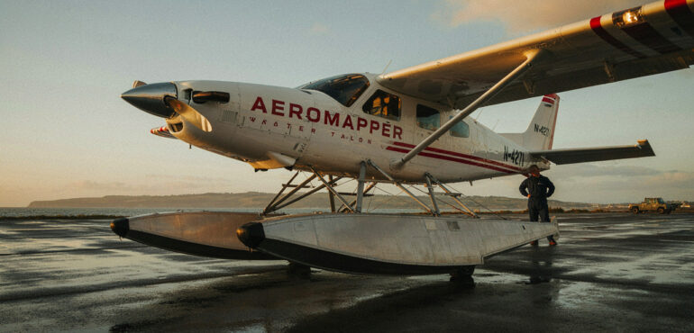
The amphibious UAV concept aims to solve these issues by being more adaptable on the water. For instance, the Aeromapper Talon Amphibious by Aeromao Inc. enables users to be more adaptable in challenging environments where water is involved. This aircraft is one of the reasons professionals can feel more at ease as they perform challenging aerial surveys.
In this post, we’ll walk through what makes this particular aircraft different, how it actually works, and where this land-to-water capability makes a real difference on the job.
What Is the Aeromapper Talon Amphibious?
The Aeromapper Talon Amphibious is a fixed-wing UAV platform we build for serious aerial mapping and data collection work. It is the basis for multiple types, and amphibian drones are built using the very same reliable foundation adapted for operations involving water bodies as well as land.
Simply put, an amphibian drone is capable of operating in both air and water according to its design and capacity characteristics. This may include landing in water, being buoyant, or even taking off from wet ground. The actual range of capabilities is usually defined by the manufacturer, so it is important to study the specifications.
An amphibious drone isn’t just a regular UAV flown near water either. It’s engineered from the ground up to interact with water safely, and that changes quite a bit about how the aircraft gets built in the first place.
What Makes the Aeromapper Talon Amphibious Unique?
Land-to-Water Operational Versatility
The development of a drone that can both fly over land and operate on the water increases flexibility in the choice of equipment to be utilized in a particular task. Factors like weather, tides, geography, and accessibility determine the process of planning and developing the platform, enabling a reduction in the necessity of compromising on something.
Enabling Aerial Survey of Hard-to-Access Areas
Drones are increasingly utilized to perform aerial photography and gather geographic information, but the area near the water implies additional planning. An appropriate amphibious UAV allows planning the work, taking into consideration the conditions, instead of adjusting the UAV to the site. In this way, the technical aspect is correlated with the practice of surveying.
Aspects of Design of Amphibious Drones
In order to develop an effective amphibious UAV, it is necessary to consider several aspects related to the airframe, buoyancy, stability, take-off/landing requirements, and payload capacity, as well as environmental requirements. All these aspects should go together in order to develop a functional product. This is the reason for the rather rare examples of amphibious UAVs.
Flexibility for Specialized Mission Planning
Different environments call for different operational approaches, and evaluating a platform against actual mission requirements tends to work far better than defaulting to one standard setup. That’s exactly the kind of flexibility amphibious capability brings to specialized aerial surveying work.
How Does the Aeromapper Talon Amphibious Work?
Autonomous Belly Landing on Water
The aircraft is built to autonomously belly land on water, and it can also land on other surfaces, including solid ground. This changes the recovery process considerably for maritime operations, since a crew no longer needs a clear runway or open field waiting at the end of a flight. As always, actual landing conditions and procedures should follow our documented operational guidance.
At Aeromao Inc., we describe the amphibious model as designed for water operations, with waterproofing and buoyancy built into the airframe itself.
Hand Launch and Autonomous Flight
The Talon amphibious supports hand launch, fully autonomous flight, automatic takeoff, mission planning, and return-to-home along with other standard flight modes. Real mission procedures still depend on configuration, environmental conditions, and whatever aviation rules apply in that operating area.
Water-Ready Construction and Protection
Waterproofing, buoyancy, and protected internal components all play a role in keeping the aircraft functional after a water landing. Our product information describes individually protected internal components along with an IP67 rating, which speaks directly to how seriously corrosion resistance was treated during design.
Key Features That Support Maritime Drone Missions
Extended Flight Endurance for Broader Coverage
The endurance of the Talon amphibious is said to be up to two hours of flight time, which is quite essential while conducting surveillance operations over a wide range. Endurance may vary due to weather conditions and configurations; however, this provides ample scope for mission planning.
Long-Range Communication and BVLOS Capability
With a communication link range past 30 kilometres, this aircraft supports Beyond Visual Line of Sight, or BVLOS, operations. Technical capability and legal authorization are two separate things, though, and BVLOS flights still require the right permissions and procedures in place. We’ve demonstrated BVLOS operations with the Talon amphibious in real field conditions, not just on paper.
Camera and Payload Flexibility
Depending on the configuration, the system can carry high-definition video, gyro-stabilized camera options, long-range video transmission, and various mapping or surveillance payloads. Which of these ships is standard versus optional depends on the specific package being discussed.
Compact and Rugged Design
Durability and compactness are crucial factors to consider when undertaking an activity in a boat or from a remote location. The ability to perform maintenance on-site, in contrast to building something flimsy, helps keep missions going and avoid having to stop because of minor problems.
Where Can the Aeromapper Talon Amphibious Be Used?
Marine research and conservation teams use the Aeromapper Talon Amphibious to monitor ecosystems, support wildlife observation, and collect aerial data in protected areas.
At Aeromao Inc., we’ve documented this aircraft in marine conservation and biodiversity research work in Belize, which speaks to real field performance rather than a lab demo, and it’s exactly the kind of proof we like to point to when someone asks whether this technology actually holds up outside a controlled test.
Beyond conservation, this same platform supports coastal and waterway mapping, where water landing adds real recovery flexibility along rivers, lakes, and shorelines. The search-and-rescue team benefits from this capability, given the aerial situational awareness that is offered by the aircraft in regions that cannot be reached.
However, it should be understood that this aircraft assists trained rescue teams and does not serve as a replacement for them. Fisheries and marine resource management make use of this capability in terms of monitoring and data collection.
Aeromapper Talon Amphibious vs. Traditional Drones: Which One to Choose?
| Consideration | Fixed-Wing UAV | Multirotor UAV |
| Flight style | Efficient forward flight | Hovering and vertical flight |
| Typical mission focus | Longer-area coverage | Close-range observation |
| Launch and recovery | Requires suitable procedures | Often supports vertical takeoff |
| Operational suitability | Depends on terrain and mission | Depends on terrain and mission |
The water recovery process will have a significant impact on the mission planning process, with impacts on recovery area specifications, the use of vessel-based deployment, water conditions, and recovery considerations. Prior to selecting an amphibious UAV, there are some important and necessary questions to ask, such as whether the mission requires landing on water, endurance needs, payload needs, BVLOS, and relevant regulations.
What Should You Consider Before Operating a Water-Landing Drone?
A few practical factors are worth checking before any mission that involves a water landing:
- Water and weather conditions: Wave height, current, wind, and visibility all affect launch, flight, and recovery.
- Obstacles and access: Confirm there’s a clear path for launch and enough room for a boat or crew to reach the recovery point safely.
- Payload and configuration: Different missions call for different sensors, so it helps to check compatibility and how each option affects flight time.
- Regulatory requirements: Maritime operations often call for trained operators and extra planning around safety, recovery, and local aviation rules.
- Recovery planning: Make sure you have a plan for recovery, with a backup in case circumstances change during the mission.
This can save you from any unpleasant surprises in the middle of the mission.
Final Thoughts
Operating in harsh terrains demands a drone with additional functionalities compared to the regular features offered by other drones. The Aeromapper Talon Amphibious provides users with both flight capability and the ability to land on either land or water. This gives users the ability to operate easily while conducting surveys, environmental studies, and remote surveillance. The water landing feature makes it an exciting choice in instances where other drones may find it difficult to recover.
With Aeromao Inc.’s drone solutions, exploring the potential of aerial data collection becomes a lot easier. If you want to elevate your surveying techniques with UAVs, try out the Aeromapper Talon Amphibious today. Contact Aeromao Inc. to configure it to your needs.
Frequently Asked Questions
What is the Aeromapper Talon Amphibious?
It’s a fixed-wing UAV designed for maritime operations, including autonomous belly landing on water and aerial data collection.
Can the Aeromapper Talon Amphibious land on water?
Yes. It’s built for autonomous belly landing on water and other surfaces, though operating conditions should follow our documented guidance.
How long can the Aeromapper Talon Amphibious fly?
It’s rated for up to two hours of endurance, with actual flight time depending on configuration and conditions.
What industries use amphibious UAVs?
Marine research, conservation, coastal surveying, fisheries management, and environmental monitoring are among the most common applications.
Is the Aeromapper Talon Amphibious suitable for BVLOS missions?
We’ve demonstrated BVLOS operations with this aircraft, though legal authorization depends on the aviation regulations in your operating area.
What should I consider before choosing an amphibious drone?
Think through mission environment, endurance needs, payloads, communication range, recovery process, and applicable regulations before committing.