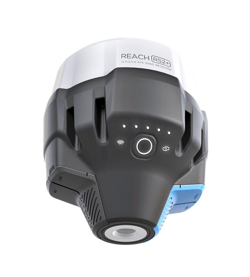
Aeromao Aeromao Aeromao
  • Home
  • About
  • PRODUCTS
    • VT-NAUT
    • Aeromapper Talon
    • Aeromapper Talon Amphibious
    • Emlid
    • DJI Drones
    • Surveying accessories
    • DJI Drones
    • Remote ID
    • Software
    • Shop
  • Services
  • Case Studies
  • News
  • Contact
  • Shop
  • 1 item

Emlid Flow

“Reach M2 with GNSS Antenna” has been added to your cart. View cart
Emlid Flow

Emlid Flow

$403.00 CAD

Mobile app
for land survey

 (Annual subscription)


Comes with a cloud-based service for keeping your data in sync.

Emlid Flow is a mobile app for iOS and Android that works seamlessly with a cloud-based service, Emlid Flow 360. The app handles all the fieldwork—receiver settings, data collection, coding, linework, and stakeout. All survey data is in sync with Emlid Flow 360 which allows you to access your projects from the browser, manage survey data and code lists.

The basic app and cloud functions come for free with a Standard subscription plan. The full list of features is available with the Survey plan for $25/month with an annual subscription—you can buy it in Emlid Flow 360.

SKU: EFSURVEY-8 Categories: Emlid, Software
  • Description
  • Reviews (0)

Description

Collect and stake out points Standard

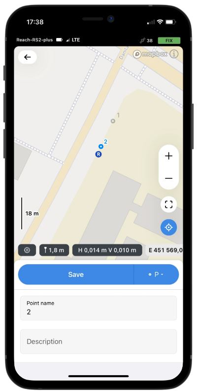
Collect points and write detailed descriptions in a few taps. To create a project for data collection, choose your coordinate system from the library or enter its parameters manually. The app supports thousands of coordinate systems, projections, grids, and geoids.

In the stakeout mode, the app displays East-North and straight-to-line distances, and supports cut and fill indications. A close-up alignment mode helps you to center precisely above the point.

Coordinate systems based on

WGS84, NAD83, GDA2020, and others
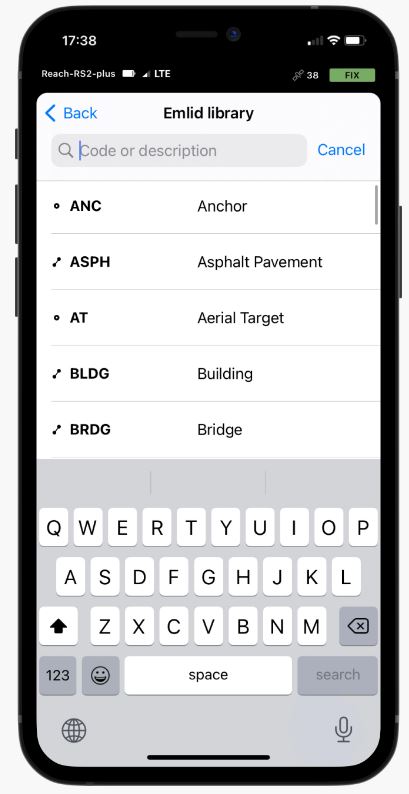


Coding Survey

To measure and describe objects, upload your custom code library or use a built-in one with more than a hundred codes. You can quickly switch between different object codes as the whole library is at your fingertips at all times. Easily create new codes on the fly right in your survey project.


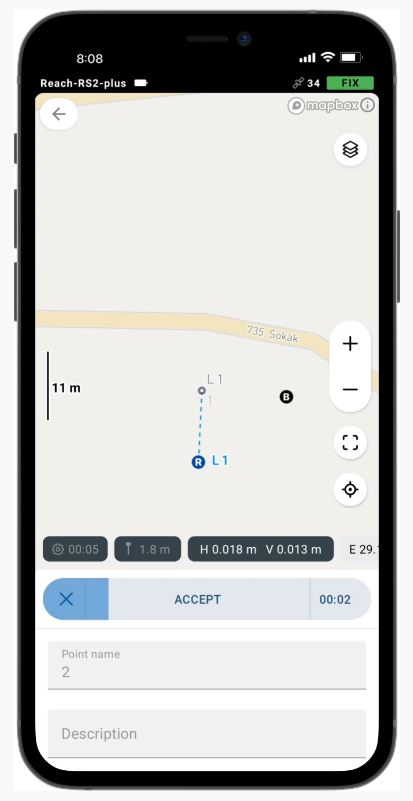
Collect and stake out lines Survey

Create linework on the go, start new lines, and continue collecting existing ones. You can use either predefined geometry types or a full-blown code library. The linework is displayed right away, so you can always see how your project is progressing.

During the stakeout, you can easily navigate to a line and check if it’s indicated correctly, stake out a line with an offset and with a chainage.


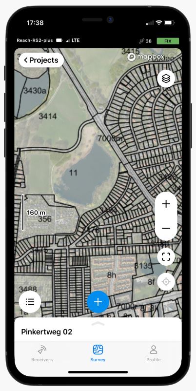
Work with different background maps

Upload topographic maps, cadastral plans, and aerial imagery from WMS and WMTS sources or work with a built-in satellite map.


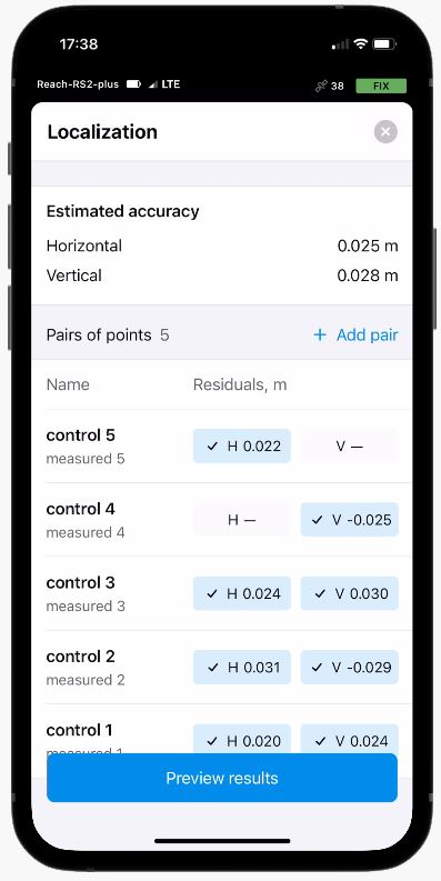
Localization: Adjust your coordinate system to fit the control points

Find or adjust missing or outdated local coordinate system parameters. Depending on the data provided, Emlid Flow automatically chooses the calibration algorithm that delivers the best accuracy.
All residuals are placed on a single screen, so you have the full context while you adjust.


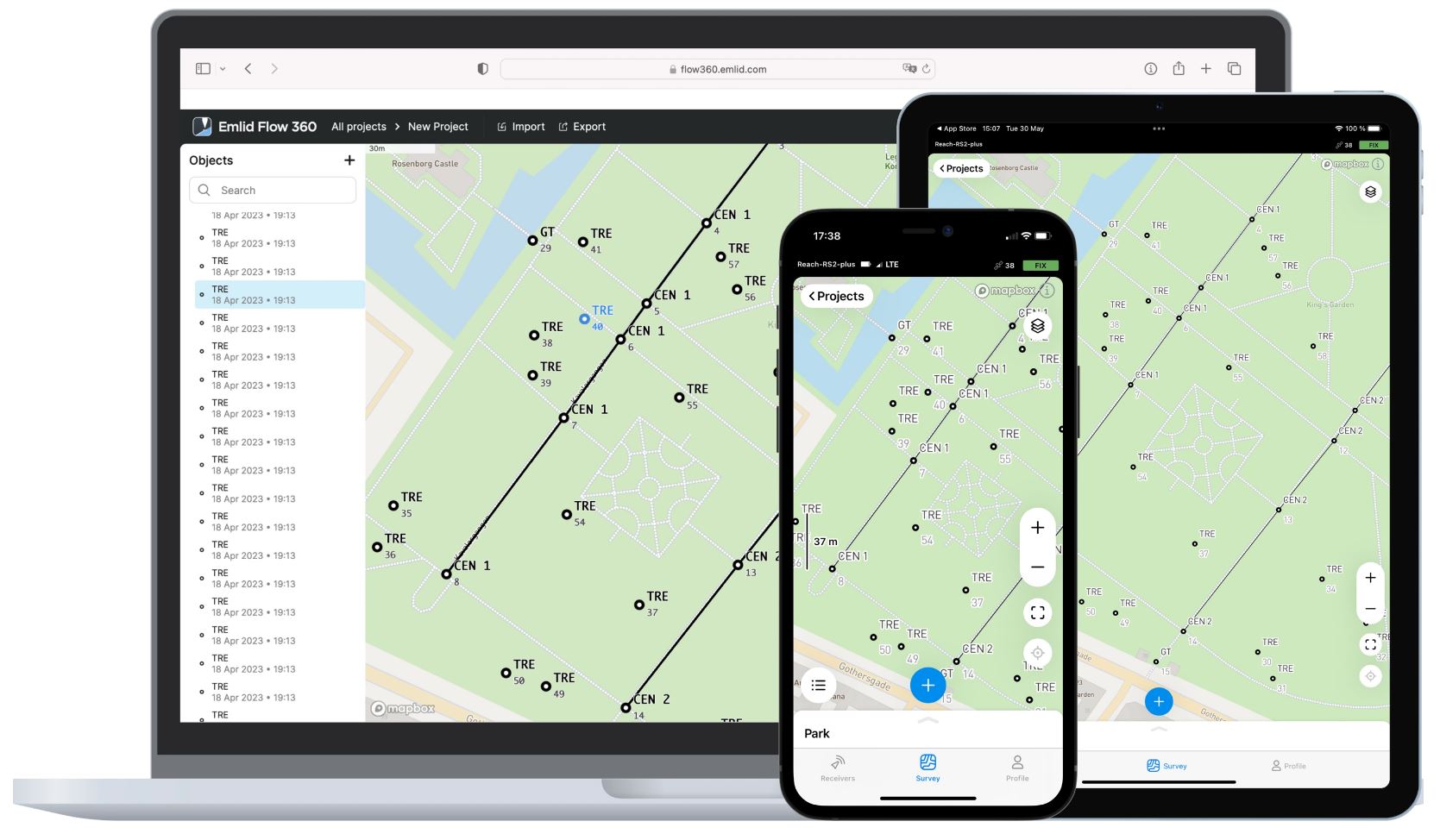
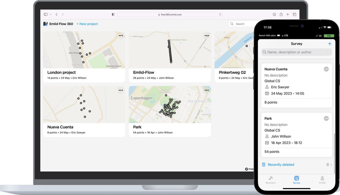
Manage your projects in the cloud Standard

The Emlid Flow app is synchronized with the Emlid Flow 360 service. This allows you to create and access survey projects, manage coordinate systems, export and import data using both the — mobile app and the cloud service at flow360.emlid.com. For data export and import, you can choose the suitable format to use in your CAD, GIS, or other survey software.


Export and import formats

CSV, DXF, and Shapefile

Manage your code libraries Survey

Import your code library to Emlid Flow 360, and it is immediately available for your projects inside the Emlid Flow mobile app. No need to check if the latest version is on the collector, it all syncs automatically.

Emlid Flow is the single app you’ll need in the field.

Configure and control Reach receivers

  • Monitor your Reach receivers
  • Configure your base and rover
  • Manage NTRIP profiles
  • Raw data logging

Sync your data and use up to 3 survey devices

Discharged smartphone isn’t a problem anymore. You can use any device with Emlid Flow!

Just log into your account and get all your projects, NTRIP profiles, and custom coordinate systems from the сloud. Your Survey subscription is also linked to your account. No additional actions are needed.


COMPARE OPTIONS

Emlid Flow (FREE)

For simple projects requiring points only or post-processing.

  • Collect and stakeout points
  • Coordinate systems, geoids, and grid shifts
  • Base shift
  • Export and import in CSV, DXF, and SHP
  • Built-in NTRIP client
  • Full control of Reach receivers

Emlid Flow 360

  • Project management and auto sync
  • Export and import of survey data

Download here:


Emlid Flow (Billed yearly)

For advanced surveying. All the benefits of Free version are included.

A single subscription for Emlid Flow and Emlid Flow 360.

  • Collect and stakeout lines
  • Add survey codes on the go
  • Use WMS/WMTS layers
  • Satellite map
  • Localization

Emlid Flow 360

  • Upload code libraries
  • Satellite map
  • Use WMS/WMTS layers


v

Reviews

There are no reviews yet.

Be the first to review “Emlid Flow”

You must be logged in to post a review.

You may also like…

  • Sale! MicroSurvey FieldGenius for WindowsMicroSurvey FieldGenius for Windows $499.00 CAD – $1,063.00 CAD Select options This product has multiple variants. The options may be chosen on the product page
    MicroSurvey FieldGenius for Windows
    $499.00 CAD – $1,063.00 CAD
  • Sale! MicroSurvey FieldGenius for AndroidMicroSurvey FieldGenius for Android $285.00 CAD – $660.00 CAD Select options This product has multiple variants. The options may be chosen on the product page
    MicroSurvey FieldGenius for Android
    $285.00 CAD – $660.00 CAD

Related products

  • Sale! Emlid Reach RS2+Emlid Reach RS2+ $3,242.00 CAD Original price was: $3,242.00 CAD.$3,229.00 CADCurrent price is: $3,229.00 CAD. Add to cart
    Emlid Reach RS2+
    $3,242.00 CAD Original price was: $3,242.00 CAD.$3,229.00 CADCurrent price is: $3,229.00 CAD.
  • Reach RS3/RS2+ LoRa antennaReach RS3/RS2+ LoRa antenna $39.00 CAD Add to cart
    Reach RS3/RS2+ LoRa antenna
    $39.00 CAD
  • Sale! Pix4D & EMLID Scanning Kit DESKTOP - w/Reach RXPix4D & EMLID Scanning Kit DESKTOP – w/Reach RX $13,213.00 CAD Original price was: $13,213.00 CAD.$9,082.00 CADCurrent price is: $9,082.00 CAD. Add to cart
    Pix4D & EMLID Scanning Kit DESKTOP – w/Reach RX
    $13,213.00 CAD Original price was: $13,213.00 CAD.$9,082.00 CADCurrent price is: $9,082.00 CAD.
Recent Posts
  • Emlid Flow Localization feature and major updates September 18, 2023
  • DJI Mavic 3E with Reach RS2+ base June 7, 2023
  • Aeromao wins Bid to supply water-landing Aeromapper Talons to United Nations FAO Philippines December 29, 2022
  • The Ocean Clean Up & Oceans Unmanned chose Aeromapper Talon Amphibious for second year in a row December 29, 2022
  • Talon Amphibious used to detect Illegal fishing December 29, 2022
  • Drones for Environmental Protection July 6, 2021
  • Aeromapper Talon Amphibious Routinely Fly BVLOS Missions Over Marine Reserve For Illegal Fishing Detection And Biodiversity Research. August 2, 2019

UAV manufacturer and developer of the unmanned aerial vehicles for mapping, surveying, precision agriculture and remote sensing.

Support : 1-647–928–4747
Mon to Fri : 9:00am – 5:00pm
Email : info@aeromao.com

Latest News

  • Emlid Flow Localization feature and major updates September 18, 2023
  • DJI Mavic 3E with Reach RS2+ base June 7, 2023
  • Aeromao wins Bid to supply water-landing Aeromapper Talons to United Nations FAO Philippines December 29, 2022

Our Products

  • VT-NAUT
  • Payloads & Accessories
  • Emlid
  • Fixed Wing Drones
  • Software
  • Surveying accessories

Social Links

payment-methods

©2024 Aeromao Inc. All Rights Reserved.
Store Policy | Terms & Conditions